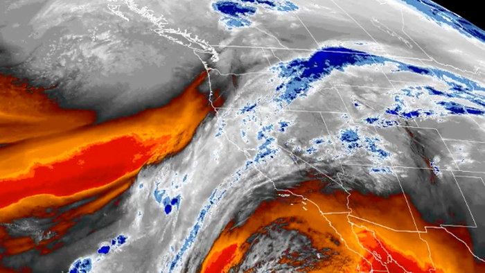
Atmospheric Rivers Pound US West Coast, Raising Bomb Cyclone Threat Ahead Of Christmas
Atmospheric Rivers Pound US West Coast, Raising Bomb Cyclone Threat Ahead Of Christmas Powerful atmospheric rivers continue to hammer Washington and Northern California, extending into Central California, dumping inches of rain, with some low-elevation areas seeing double-digit totals, while higher elevations are getting buried under heavy snowfall. Here is this week's forecast via The Weather Channel: Atmospheric rivers continue to soak the West, bringing heavy rainfall, gusty winds and mountain snowfall. The latest event is ramping up for Northern and Central California this weekend and is expected to last into the week. Flood watches are in effect through the next several days, where widespread rainfall of 5 to 8 inches is possible through Thursday and isolated totals could near a foot. Cities like Sacramento, Los Angeles and San Francisco could see a month's worth of rainfall this upcoming week. Mountain snowfall is also possible across the Cascades and the Sierra Nevada. US Stormwatch founder Colin McCarthy warned that a bomb cyclone could form off the coast of California on Christmas Eve... A bomb cyclone is likely to develop off the coast of California Christmas Eve that could bring a severe windstorm to Northern California. High Wind Watches have just been issued for the entire Bay Area for wind gusts up to 60 mph, but if more agressive model forecasts pan out wouldn't be shocked to see 70+ mph in the higher terrain and along the coastline. A very strong cold front with potentially embedded severe thunderstorms will also come ashore late Tuesday night/early Wednesday morning in Central/Northern California that could mix very intense 60+ mph wind gusts to the surface. Given strong wind shear, can also not rule out a tornado or two. A bomb cyclone is likely to develop off the coast of California Christmas Eve that could bring a severe windstorm to Northern California. - Colin McCarthy (@US_Stormwatch) High Wind Watches have just been issued for the entire Bay Area for wind gusts up to 60 mph, but if more agressive model forecasts pan out... pic.twitter.com/DWnvkt8KbG December 22, 2025 Meteorologist Brady Harris published a forecast that showed parts of the Nevada Mountain Range this week could receive "more than 8 FEET!" ⚠️ A LUDICROUS amount of Snow is likely in the Sierra Nevada Mountain Range this week. Higher elevations could see OVER 100 INCHES of Snow. That's... more than 8 FEET ❄️ - Brady Harris (@StormCat5_) Multiple waves of Heavy Snow will fall as a PARADE OF STORMS slams California , one after another. Storm 1⃣... pic.twitter.com/eAsmTNe4XO December 22, 2025 "So far we haven't had much snow in the Sierra, but that is about to change," legendary meteorologist Jim Cantore said. A long week of HEAVY RAIN and HEAVY MOUNTAIN SNOW for California. The whole state gets it too. Late tomorrow the snow levels begin to drop and those watches will become warnings for 5500 feet on up as a series of high end AR's (atmospheric river) punches in. - Jim Cantore (@JimCantore) So far we haven't... pic.twitter.com/ThCZTqVVlh...
Preview: ~500 words
Continue reading at Zerohedge
Read Full Article